前言
欢迎来到这篇 Vala 和 GTK4 的实战教程!1
许多入门教程止步于“Hello, World!”或简单控件演示,这样一方面各部分间缺乏组织逻辑,不便进行复杂演示,另一方面也难以指导读者开发一个真正实用、现代、体验良好的应用。本教程将通过一个完整的项目案例,带你从需求分析、界面设计、核心算法、异步网络、数据导出等多个维度,系统梳理依托 GLib/GObject 世界生态的 Vala 开发流程。
本教程适合有一定编程基础,希望深入学习 Vala 语言和最新的 GTK4、LibAdwaita 等开发框架,并渴望开发高质量应用的开发者。如果你还不熟悉 Vala 语言,可以阅读 Vala 官方文档,如果想查阅基础库的使用方法,可以参考 Valadoc.org 提供的 API 参考,也欢迎阅读笔者先前写的 GTK/Vala 开发基础教程与 GTK/Vala 开发基础教程 2。
本教程将以笔者实现的“太阳计算器”的完整应用为例,深入剖析其从概念设计到功能实现的每一个环节。这个应用不仅能进行科学计算,还拥有一个使用 LibAdwaita 构建的、支持深色模式的现代化用户界面,并具备异步网络请求、JSON 解析、自定义绘图和文件导出等高级功能。
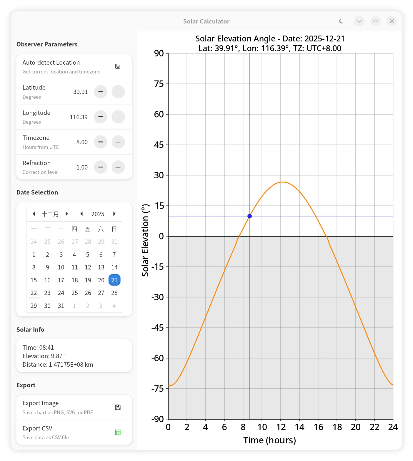 |
 |
|---|---|
| 太阳高度角计算器(浅色模式) | 太阳高度角计算器(深色模式) |
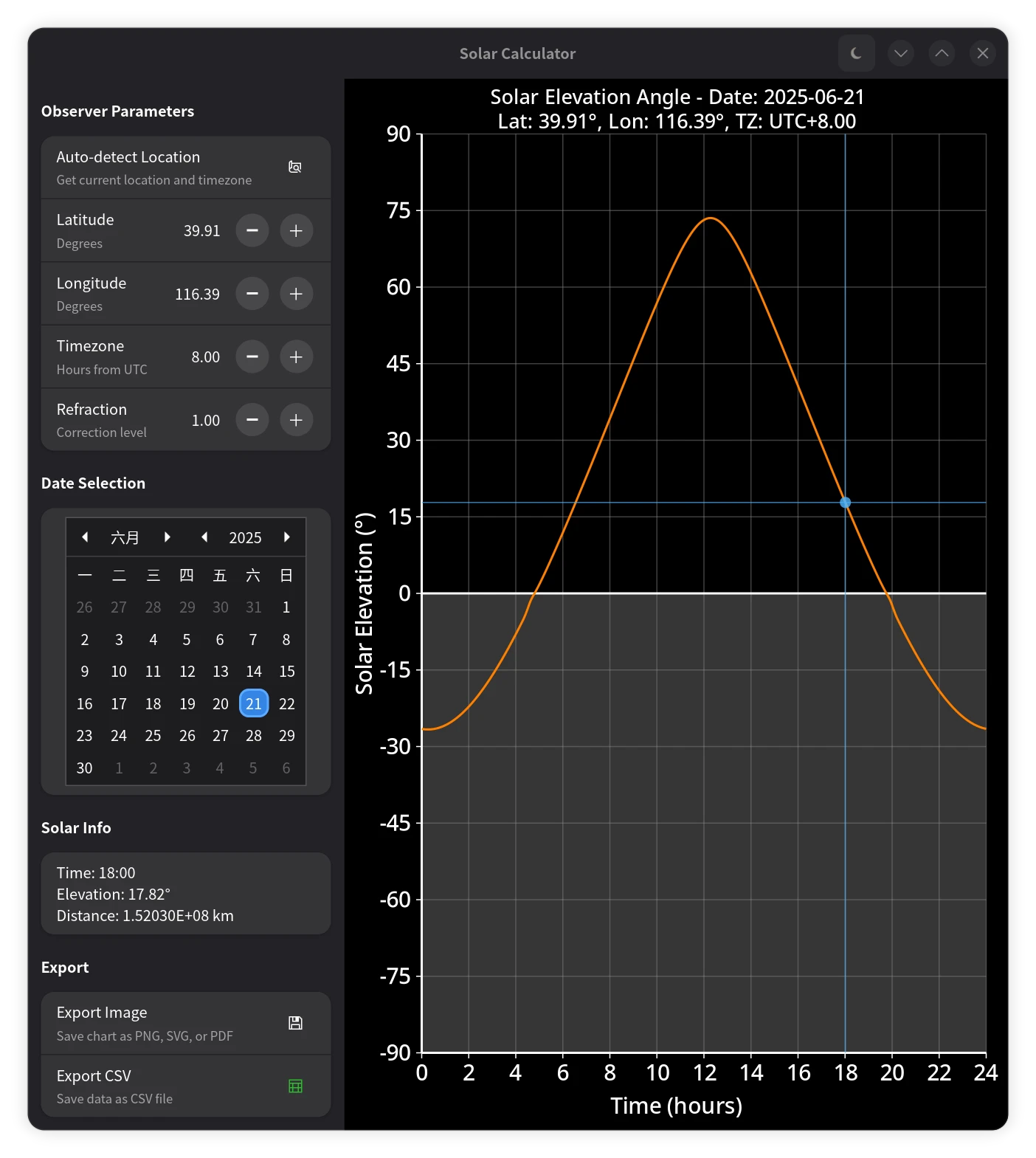
 |
 |
| 获取地理位置时的加载动画 | 提示与选择 |
通过本教程,你将学到:
- Vala 语言的核心特性:面向对象、信号与槽、异步编程等。
- GTK4 和 LibAdwaita:如何构建响应式、符合现代 GNOME 设计规范的 UI。
- Cairo 图形库:如何在
Gtk.DrawingArea上绘制自定义图表。 - 异步网络编程:如何在 Vala 中使用
async和yield从网络 API 获取数据而不会冻结 UI。 - JSON-GLib:如何轻松解析网络返回的 JSON 数据。
- 文件 I/O:如何使用
Gtk.FileDialog和 Cairo 将图表导出为图片(PNG/SVG/PDF),以及如何将数据保存为 CSV 文件。
让我们开始这段激动人心的旅程吧!
第一部分:应用概念与设计
在编写任何代码之前,清晰地构思应用的功能和设计是至关重要的。
应用目标
我们的目标是创建一个工具,能够:
- 接收用户输入的地理位置(经纬度)、时区和日期。
- 计算出该地点在指定日期内,一天中每一分钟的太阳高度角。
- 将计算结果以直观的图表形式可视化展示出来。
- 提供交互功能,用户可以点击图表上的任意点,查看具体时间的太阳高度角。
- 支持自动定位功能,通过网络服务获取用户当前位置。
- 允许用户将图表导出为图片,或将原始数据导出为 CSV 文件。
- 对于特殊情况,应当为用户提供友好的提示。
UI/UX 设计哲学
为了让应用看起来现代化且用户友好,我们选择使用 LibAdwaita。它是 GTK4 的一个辅助库,旨在帮助开发者构建遵循 GNOME 人机界面指南 (HIG) 的应用。
我们的界面布局采用常见的双栏结构:
- 左侧面板:作为控制中心,包含所有输入控件(经纬度、时区、日期选择器)和操作按钮(导出、自动定位)。我们使用
Adw.PreferencesGroup来组织这些设置,使其清晰明了。 - 右侧主区域:用于展示核心内容——太阳高度角图表。这部分将使用
Gtk.DrawingArea进行完全的自定义绘制。
这种设计不仅结构清晰,也为未来可能的响应式布局(例如在小屏幕上将左侧面板收起到侧边栏)打下了基础。
现代桌面应用越来越重视主题一致性和深色模式支持。LibAdwaita 天生支持系统主题切换,能够自动适配浅色/深色模式,为用户带来舒适的视觉体验。在本项目中,我们不仅让应用自动响应系统主题,还在标题栏右上角提供了深色模式切换按钮,用户可以随时手动切换浅色/深色界面。
主题切换的实现思路如下:
- 通过
Adw.StyleManager检测当前系统主题(dark属性)。- 如果用户没有手动切换深浅色主题,本应用的深浅色将跟随系统主题,并随系统主题改变而改变。
- 在
HeaderBar添加一个Gtk.ToggleButton,点击时切换color_scheme属性,实现强制浅色或深色。- 用户手动指定主题后,程序深浅色主题将不再跟随系统变化。
- 所有 Cairo 自定义绘图都根据当前主题动态选择配色方案,确保视觉风格统一。
- 主题切换时,主动触发重绘,保证界面即时更新。
这种做法不仅让应用外观与系统保持一致,也为自定义控件和绘图区域带来了良好的主题适配体验。
第二部分:项目设置与编译
Vala 代码需要被编译成 C 代码,然后再编译成可执行文件。Vala 编译器 valac 会为我们处理好这一切。
读者不妨先编译并试用该应用,再继续阅读。这样可以更好地理解每个功能的意义。
依赖项
完成本教程涉及的代码编译需要确保系统已安装 Vala、GTK4、LibAdwaita,用于 JSON 解析的 json-glib 库,以及 C 编译工具(如 gcc);在 Linux 下,还需要额外安装在 GLib/GIO 中实现网络访问的 gvfs 库(Windows则不需要)。笔者在此列举了在 Arch Linux 和 Windows MSYS2 环境下的安装命令:
- Arch Linux:
sudo pacman -S --needed vala gtk4 libadwaita json-glib gvfs - Windows MSYS2:
在 MSYS2 UCRT64 环境中:
pacman -S --needed mingw-w64-ucrt-x86_64-vala mingw-w64-ucrt-x86_64-gcc mingw-w64-ucrt-x86_64-gtk4 mingw-w64-ucrt-x86_64-libadwaita mingw-w64-ucrt-x86_64-json-glib
我们的应用的编译参数还可以指定到文件的 Shebang 中,这样在 Linux 操作系统上授予可执行权限后直接执行源代码时,Vala 编译器会自动帮你编译并运行程序,一条龙完成。(Windows不支持 Shebang)
对于不熟悉 Shebang 的读者:Shebang 是 Unix/Linux 系统中脚本文件的第一行,用于指定可执行文件的解释器。例如,#!/usr/bin/env -S vala 表示使用 vala 编译器来执行该脚本。需要注意的是,虽然看起来像是直接运行 Vala 代码,但实际上它会在后台调用 valac 编译器来处理代码,并不涉及解释执行。
#!/usr/bin/env -S vala --pkg=gtk4 --pkg=libadwaita-1 --pkg=json-glib-1.0 -X -lm -X -O2 -X -march=native -X -pipe
--pkg=gtk4: GTK4 核心库,用于构建 UI。--pkg=libadwaita-1: LibAdwaita 库,用于现代化窗口和控件。--pkg=json-glib-1.0: GLib 的 JSON 支持库,用于解析 JSON 数据。-X -lm: 传递-lm链接选项给 C 编译器,因为我们的计算代码使用了数学库 (math.h)。-X -O2 -X -march=native -X -pipe: 这些是传递给 C 编译器的参数。在脚本中应用编译优化存在一些独特考量:-O2提供了良好的优化级别,既明显提升运行时性能,又避免激进优化可能导致的编译时间显著延长 —— 这点尤为重要,因为每次通过 Shebang 直接执行脚本都会重新编译,编译耗时直接影响用户体验;-march=native利用当前 CPU 的全部指令集特性进行优化。由于编译产物仅在当前机器上运行且不被保留,不存在跨设备兼容性风险,这有望带来本地性能提升。
编译与运行
读者可以将教程最后的完整代码保存为 solarcalc.vala,或者使用wget命令直接下载:
wget https://raw.githubusercontent.com/wszqkzqk/FunValaGtkExamples/master/solarcalc.vala
你可以直接运行这个脚本文件(如果它有执行权限 chmod +x solarcalc.vala),或者使用以下命令手动编译,避免每次运行前都自动编译带来的启动延迟:
valac --pkg=gtk4 --pkg=libadwaita-1 --pkg=json-glib-1.0 -X -lm -X -O2 -X -pipe solarcalc.vala
需要注意的是,与“执行”用的 vala 不同,编译需要使用 valac 命令。对于 Windows 用户,如果不希望程序运行的时候总是额外带着一个命令行窗口,可以额外添加 -X -mwindows 参数。
第三部分:构建用户界面
现在,让我们深入 activate 方法,看看 UI 是如何一步步构建起来的。
应用与主窗口
基于 LibAdwaita/GTK4 的应用的入口点是一个继承自 Adw.Application 的类。在 activate 方法中,我们创建了主窗口 Adw.ApplicationWindow。
public class SolarCalc : Adw.Application {
    private Adw.ApplicationWindow window;

    // ...

    protected override void activate () {
        window = new Adw.ApplicationWindow (this) {
            title = "Solar Calculator",
        };
        // ...
        window.present ();
    }
}
布局结构:Adw.ToolbarView
我们使用 Adw.ToolbarView 作为顶级布局容器。它天生支持顶部栏(HeaderBar)和主内容区域,是构建现代 LibAdwaita 应用的理想选择。Adw.HeaderBar作为应用的顶部栏,不仅承载了窗口标题,还提供了放置按钮等交互元素的区域。在本应用中,我们利用 Adw.HeaderBar 来显示应用标题,并在其右侧集成了深色模式切换按钮,为用户提供便捷的主题控制。
var header_bar = new Adw.HeaderBar ();
// Add dark mode toggle button
var dark_mode_button = new Gtk.ToggleButton () {
    icon_name = "weather-clear-night-symbolic",
    tooltip_text = "Toggle dark mode",
    active = style_manager.dark,
};
// ...
header_bar.pack_end (dark_mode_button);

var toolbar_view = new Adw.ToolbarView ();
toolbar_view.add_top_bar (header_bar);

// ... main content ...

window.content = toolbar_view;
左侧输入面板
左侧面板是一个垂直的 Gtk.Box,为了适应不同屏幕尺寸,我们将其包裹在 Gtk.ScrolledWindow 中。面板内包含了几个 Adw.PreferencesGroup,用于对设置项进行逻辑分组。这些控件负责收集用户输入,并提供操作入口。
处理加载状态:Gtk.Stack 与 Gtk.Spinner
在现代应用中,为耗时操作(如网络请求)提供即时反馈至关重要。当用户点击“自动获取位置”时,我们不希望界面冻结无响应,也不希望界面无反应。一个常见的模式是在操作期间用一个加载指示器(如提供旋转加载动画的 Gtk.Spinner)替换原始控件(如 Gtk.Button)。
然而,一个朴素的实现——简单地移除按钮并添加 Gtk.Spinner——可能会导致界面布局发生变化,因为两个控件的大小可能不同。这会造成视觉上的“抖动”,影响用户体验。
为了解决这个问题,我们采用了一种更优雅的方案:Gtk.Stack。Gtk.Stack 是一个容器,它一次只显示其众多子控件中的一个,就像一叠卡片。将按钮和 Gtk.Spinner 都放入同一个 Gtk.Stack 中,并设置其 hhomogeneous 和 vhomogeneous 属性为 true 时,Gtk.Stack 会确保其分配的空间足以容纳其最大的子控件,并让所有子控件都占用同样大小的空间。此外,设置 transition_type 为 Gtk.StackTransitionType.CROSSFADE 可以实现平滑的淡入淡出过渡效果。
// Use a stack to keep consistent allocation and avoid layout jitter
location_stack = new Gtk.Stack () {
    hhomogeneous = true,
    vhomogeneous = true,
    transition_type = Gtk.StackTransitionType.CROSSFADE,
};
location_spinner = new Gtk.Spinner ();
location_button = new Gtk.Button () { /* ... */ };

location_stack.add_child (location_button);
location_stack.add_child (location_spinner);
location_stack.visible_child = location_button;
这样,当我们通过 location_stack.visible_child = location_spinner; 在按钮和加载器之间切换时,容器的尺寸保持不变,从而彻底消除了界面抖动。再配合 transition_type 设置一个淡入淡出的过渡效果,用户体验就非常平滑了。
输入与交互控件
- 输入控件
Adw.SpinRow:对于经纬度、时区以及大气折射系数这类数值输入,Adw.SpinRow是一个非常合适的控件。它将一个标签、一个描述和一个数值调节器组合在一起,美观且便于使用。latitude_row = new Adw.SpinRow.with_range (-90.0, 90.0, 0.1) { title = "Latitude", subtitle = "Degrees", value = latitude, digits = 2, };我们通过监听其
notify::value信号来响应用户的输入变化。当值改变时,我们更新内部变量并重绘图表。Vala 语言支持信号与槽机制,这使得响应用户交互变得非常简单。此外,Vala 还可以很方便地使用 lambda 匿名函数来简化代码。latitude_row.notify["value"].connect (() => { latitude = latitude_row.value; update_plot_data (); drawing_area.queue_draw (); }); - 日期选择
Gtk.Calendar:Gtk.Calendar控件提供了直观的日期选择功能,用户可以直接在日历界面中选择所需要的日期。我们将其放入一个Adw.ActionRow中,以保持与其他设置项风格的统一。
右侧绘图区域
右侧区域的核心是 Gtk.DrawingArea。它本质上是一块空白画布,我们可以通过 set_draw_func 注册一个绘图函数,来控制其显示内容。
drawing_area = new Gtk.DrawingArea () { /* ... */ };
drawing_area.set_draw_func (draw_sun_angle_chart);
每当需要重绘时(例如窗口大小改变、数据更新),这个函数就会被调用。此外,在需要的时候,我们也可以通过 drawing_area.queue_draw() 主动发起一次重绘。
第四部分:核心功能实现
现在,我们来实现应用的核心功能:计算与表达。
太阳参数计算
本程序使用基于 Meeus 在 《天文算法》 (Astronomical Algorithms) 一书中提出的实现,能在不依赖大型星历表的情况下,达到很不错的精度。笔者进行了实测:分散选取南北半球低中高纬度共6个不同的代表性位置,在 1975-2075 的 100 年间,测试其中每个整时刻的高度角计算值与公认高精度的专业天文库 Astropy 的结果的误差,测试数据点高达 5,312,160 个。测试发现整体上高度角基本不存在系统性的偏差,RMSD 仅 0.0030°,95% 的误差绝对值不超过 0.0058°,如广泛此的数据中最大误差绝对值也仅为 0.0121°。对于站心距离计算,RMSD 为 2804 km,95% 的误差绝对值为 5332 km,最大误差绝对值为 7611 km,主要是金星、木星等行星的较长周期的摄动所致。考虑到太阳距离地球约 1.5 亿公里,这样的误差已经非常小了,足以满足绝大多数业余天文观测和日常应用的需求。 如果你对算法的理论背景、实现细节及其在 Vala 语言中的最佳实践感兴趣,请移步阅读笔者的续篇教程:Vala 数值计算实践:高精度太阳位置算法。
generate_sun_angles 函数是应用计算的核心。笔者在此实现了 Meeus 算法的等价变体,通过精确的天体力学模型计算太阳位置。这个算法较简单,但具有很高的精度,适合我们这个应用的需求。
 |
|---|
 |
| 本程序实现的 Meeus 算法相对专业天文库 Astropy 的误差分布直方图 |
时间基准:从 J2000.0 历元起算的天数
天文计算需要统一的时间标尺。我们使用 J2000.0 历元(2000 年 1 月 1 日 12:00 UTC)作为参考点,由于 GLib 的 DateTime.get_julian () 方法返回的儒略日是从公元1年1月1日开始计算的(注意不是常见的公元前4713年),我们需要将其转换为相对于 J2000.0 的天数:
var date = new GLib.Date ();
date.set_dmy (day, month, year);
var julian_date = (double) date.get_julian ();
double base_days_from_epoch = julian_date - 730120.5; // 当天 00:00 UTC 到 J2000.0 的天数
黄赤交角 (Obliquity of the Ecliptic, $\epsilon$)
地球自转轴相对黄道的倾角,随时间微小变化:
\[\epsilon_\text{degrees} = 23.439291111 - 0.0000003560347 d - 1.2285 \times 10^{-16} d^2 + 1.0335 \times 10^{-20} d^3\]轨道参数:平黄经 ($L$) 和平近点角 ($M$)
- 平黄经:描述理想化匀速圆周运动下的“平均太阳”在黄道上的位置,从春分点开始计算
- 平近点角:描述理想化匀速圆周运动下的“平均太阳”在轨道上从近地点出发的角度
中心差修正与真黄经 ($\lambda$)
考虑地球椭圆轨道的影响,通过中心差 $C$ 将平黄经修正为真黄经 $\lambda$:
\[C_\text{degrees} = (1.914602 - 0.00000013188 d - 1.049 \times 10^{-14} d^2) \sin(M) + (0.019993 - 0.0000000027652 d) \sin(2M) + 0.000289 \sin(3M)\] \[\lambda = L + C\]坐标转换:赤纬 ($\delta$) 和赤经 (RA)
从黄道坐标系转换到赤道坐标系:
\[\sin(\delta) = \sin(\epsilon) \sin(\lambda)\] \[RA = \text{atan2}(\cos(\epsilon) \sin(\lambda), \cos(\lambda))\]均时差 (Equation of Time, $EoT$)
均时差描述真太阳时与平太阳时之间的差异,主要由地球椭圆轨道和黄赤交角共同引起。通过平均时角(平黄经对应的时角)与太阳赤经的差值计算:
\[EoT_\text{minutes} = (T_\text{mean,hours} - RA_\text{hours}) \times 60\]其中,平均时角 $T_\text{mean,hours} = L / 15°$,赤经 $RA_\text{hours}$ 则由前述坐标转换得出。
真太阳时 (True Solar Time, $TST$)
考虑均时差和经度修正,将本地钟表时间转换为真太阳时:
\[TST_\text{minutes} = T_\text{local,minutes} + EoT_\text{minutes} + 4 \times \lambda_\text{longitude,degrees} - 60 \times TZ_\text{hours}\]时角 (Hour Angle, $HA$) 与太阳高度角 ($\alpha$)
- 时角描述太阳相对本地子午线的角距离:$HA_\text{degrees} = TST_\text{minutes} / 4 - 180$
- 结合观测地纬度 $\phi$、太阳赤纬 $\delta$ 和时角 $HA$,使用球面三角公式计算高度角:
地心视差修正 (Geocentric Parallax Correction)
上述公式计算出的高度角是基于地心坐标系的,假设观测者位于地球中心。然而,实际观测者位于地球表面。由于地球半径的存在,对于地表观测者来说,天体的位置会显得比地心视角略低,这种差异称为周日视差。
虽然太阳距离地球很远(约 1 AU),视差很小,但其最大值(太阳在地平线时)仍可达 $8.794$ 角秒(约 $0.00244^\circ$)。对于追求高精度的计算,这是一个不可忽略的系统误差。
本程序进行了如下修正,将地心高度角转换为站心高度角:
\[\alpha_\text{topo} = \alpha_\text{geo} - 0.00244^\circ \times \cos(\alpha_\text{geo})\]在代码中,我们直接利用计算出的 $\cos(\alpha)$ 进行修正:
double elevation_cos = Math.sqrt (1.0 - elevation_sin * elevation_sin);
double geocentric_parallax_deg = 0.00244 * elevation_cos;
// 最终高度角 = 地心高度角 - 视差
sun_angles[i] = Math.asin (elevation_sin) * RAD2DEG - geocentric_parallax_deg;
如果不加这一修正,在上文的误差分布直方图中,RMSD 会从 0.0030° 增加到约 0.0036°,且误差平均值与分布中心将会偏离至 0.0020° 左右,在本程序的精度下十分明显。
大气折射修正 (Atmospheric Refraction Correction)
除了视差,大气折射也是影响地基观测的重要因素。当光线穿过地球大气层时,由于大气密度的变化,光线会发生弯曲,使得天体的视位置比真位置要高。
本程序使用了 Saemundsson 公式 来估算大气折射量 $R$(单位:度):
\[R = 1.02 \cot \left( h + \frac{10.3}{h + 5.11} \right) \times \frac{1}{60}\]其中 $h$ 是真高度角(单位:度)。值得注意的是,该公式在数学上存在适用范围。当真高度角 $h$ 过低(小于约 -5.0015°)或接近天顶(大于约 89.8915°)时,公式计算出的修正值会变为负数,不合理。因此,我们在代码中加入了范围检查,仅在 $-5.0015^\circ < h < 89.8915^\circ$ 的范围内应用此修正,超出范围则视为无折射。Saemundsson 公式精度良好,在从天顶到地平线的整个范围内,误差小于 0.1’(约 0.0017°)。
考虑到大气折射受温度、气压等气象条件影响较大,我们在界面上提供了一个 Refraction 调节项(refraction_factor),允许用户调整折射修正的强度。设置为 1.0 表示标准大气条件下的修正,设置为 0.0 则关闭修正。
需要注意的是,前文提到的精度验证是在无大气折射的理想情况下进行的,验证的是真实的几何角度而非目测角度。开启大气折射修正后,计算结果将更接近目测值,但具体偏差将取决于实际的大气环境。
算法对一天中每一分钟都进行采样计算,将结果存储在 sun_angles 数组中,为后续的可视化和交互提供数据支持。
站心距离计算 (Topocentric Distance Calculation)
除了太阳的方位,我们还可以计算地球上的观测者到太阳的距离。这需要地球轨道的离心率 $e$ 和真近点角 $\nu$。
地球轨道的离心率 $e$ 随时间微小变化:
\[e = 0.016708634 - 1.15091 \times 10^{-9} d - 9.497 \times 10^{-17} d^2\]真近点角 $\nu$ 是从近地点开始计算的角度,它等于平近点角 $M$ 和中心差 $C$ 的和:
\[\nu = M + C\]有了离心率和真近点角,就可以计算出以天文单位(AU)为单位的日地距离(实际上是地月系质心到太阳的距离):
\[R_\text{EMB} = \frac{1 - e^2}{1 + e \cos(\nu)}\]其中 $R_\text{EMB}$ 是地月系质心到太阳的距离(单位:天文单位 AU)。
为了使得计算结果可以解答经典有趣的“两小儿辩日”中关于早晨与中午太阳距离的争论,我们进一步精确计算了站心距离,即观测者直接到太阳的距离。这需要引入了两个修正项:
-
月球摄动修正:利用月球平距角 $D$ 估算地球相对于地月系质心的位置,将地月系质心距离修正为地心距离。这一摄动周期约为 29.53 天(朔望月),幅度约为 4671 km。其中月球平距角 $D$ 的计算公式为:
\[D_\text{degrees} = 297.8501921 + 12.190749114398 d - 1.41064 \times 10^{-12} d^2 + 3.7596 \times 10^{-20} d^3\] -
站心修正:考虑到地球半径 $R_\text{Earth}$(约 6371 km),这将导致当太阳处于高地心高度角时比在低地心高度角时更近。在代码实现中,我们直接复用了前文计算地心高度角时得到的正弦值
elevation_sin(即 $\sin(\alpha)$),这不仅简化了计算,也避免了重复调用三角函数带来的开销。
综合计算公式如下(结果转换为千米):
\[R_\text{topo} \approx 149597870.7 R_\text{EMB} - R_\text{Earth} \sin(\alpha) + 4671 \cos(D)\]其中 $149597870.7$ 为 1 AU 对应的千米数。
经过这些修正,本程序的计算结果不仅精度更高,更能直观反映一天中日地距离随时间的变化,从而通过科学计算回答太阳到底是早晨还是中午更近的问题。
“两小儿辩日”问题由于椭圆轨道、地球半径、所在位置的影响,实际结论会因地点和日期而异。在太阳高度角更高时,观测者距离太阳更近;此外,由于地球轨道的离心率,当地球运行在不同轨道位置时,日地距离也会有所不同。综合考虑这些因素后,在不同的地点和日期,会得出不同的结论。
本程序虽然在距离计算上看似存在上千千米的误差,与一天内的距离变化量级相当,但实际上,这些误差主要来源于行星摄动等较长周期的复杂因素,这些长期摄动在一天之内几乎没有相对变化,并不影响对日地距离在一天中变化趋势的正确判断。
自定义绘图与 Cairo
draw_sun_angle_chart 函数是应用的绘制核心。它接收一个 Cairo.Context 对象(通常简写为 cr),你可以把它想象成 Cairo 的画笔,拥有颜色、粗细、字体等属性。
绘图过程遵循一个清晰的层次结构:
- 主题颜色:我们定义了一个
ThemeColors结构体,并准备了LIGHT_THEME和DARK_THEME两套颜色。在绘图开始时,根据style_manager.dark的状态选择合适的颜色方案,实现了对系统深色/浅色模式的自适应。 - 绘制背景和坐标系:首先填充背景色,然后绘制网格线、坐标轴和标签。这里大量使用了
cr.move_to(),cr.line_to(),cr.stroke()等基本绘图命令。对于文本,cr.show_text()用于绘制,cr.text_extents()用于测量文本尺寸以实现精确定位。 - 绘制数据曲线:这是最关键的一步。我们遍历
sun_angles数组,将每个数据点(时间 -> x, 角度 -> y)转换为画布上的像素坐标,然后用cr.line_to()将这些点连接起来,形成平滑的曲线。 - 绘制交互点:如果用户点击了图表 (
has_click_point为true),我们会在对应位置绘制一个圆点和十字参考线,为用户提供即时反馈。 - 绘制标题:在图表顶部添加动态标题,显示当前的日期和位置信息。
交互式图表:Gtk.GestureClick
为了响应用户的点击,我们给 drawing_area 添加了一个 Gtk.GestureClick 控制器。
var click_controller = new Gtk.GestureClick ();
click_controller.pressed.connect (on_chart_clicked);
drawing_area.add_controller (click_controller);
在 on_chart_clicked 回调函数中:
- 获取点击的
x,y坐标。 - 将
x坐标从像素值转换回一天中的时间(小时)。 - 根据时间从
sun_angles数组中查找到对应的太阳高度角。 - 更新
click_info_label的文本,显示选定点的信息(时间、太阳高度角和地日距离)。 - 设置
has_click_point = true并调用drawing_area.queue_draw(),请求重绘以显示点击标记。
异步网络请求与 JSON 解析
自动定位功能是本应用的一个亮点,它完美地展示了 Vala 强大的异步处理能力:网络请求是耗时的 I/O 操作,如果我们在主线程中直接请求,在收到网络响应前整个应用的 UI 会被冻结,这会带来极差的用户体验;因此,我们使用 Vala 的异步编程特性来处理这一问题。
- Vala 的
async/yield: Vala 借鉴了 C# 的async/await语法,使得异步编程像写同步代码一样直观。- 我们将网络请求逻辑放在一个
async方法get_location_async中。 - 当遇到耗时操作时(如
file.read_async),我们使用yield关键字。这会“暂停”当前方法的执行,将控制权交还给主事件循环(让 UI 保持响应),当 I/O 操作完成后,方法会自动从yield的地方继续执行。 - 为了避免网络请求长时间无响应,我们还引入了超时机制。通过
GLib.Cancellable和GLib.Timeout.add_seconds,我们可以在指定时间(例如 5 秒)后取消网络请求,并向用户显示错误信息,提升应用的健壮性。private async void get_location_async () throws IOError { var file = File.new_for_uri ("https://ipapi.co/json/"); var parser = new Json.Parser (); // 设置 5 秒超时 var cancellable = new Cancellable (); var timeout_id = Timeout.add_seconds_once (5, () => { cancellable.cancel (); }); try { var stream = yield file.read_async (Priority.DEFAULT, cancellable); // ... } catch (Error e) { // ... } finally { // 取消超时回调 if (!cancellable.is_cancelled ()) { Source.remove (timeout_id); } } }
- 我们将网络请求逻辑放在一个
- JSON-GLib 解析:
JSON-GLib 提供了一套健壮的 API 来遍历和提取 JSON 结构中的数据,并能很好地处理潜在的错误。获取到网络响应后,我们使用
Json.Parser来解析它。得益于 JSON-GLib 与 GLib/GObject/GIO 生态的强大集成,我们可以直接方便地使用parser.load_from_stream_async从网络流中异步加载和解析 JSON 数据,无需手动处理字节流。var parser = new Json.Parser (); yield parser.load_from_stream_async (stream, cancellable); var root_object = parser.get_root ().get_object (); if (root_object.has_member ("latitude") && root_object.has_member ("longitude")) { latitude = root_object.get_double_member ("latitude"); longitude = root_object.get_double_member ("longitude"); } else { throw new IOError.FAILED ("No coordinates found in the response"); } // ... - 时区冲突处理:
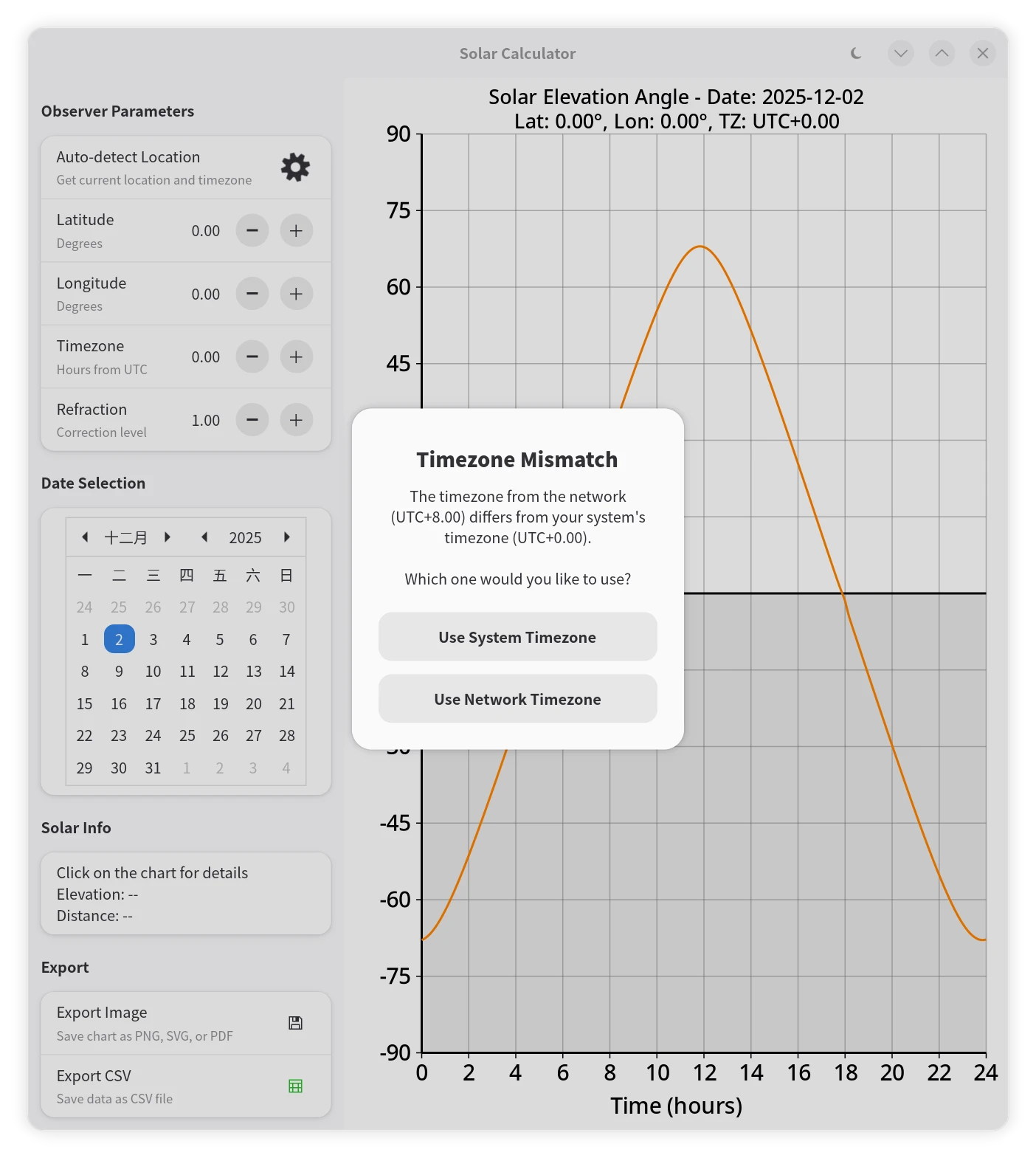
在自动定位时,网络服务返回的时区信息可能与用户系统当前设置的时区不同。为了提供更好的用户体验,应用会检测这种差异。如果发现网络时区与系统时区不一致,应用会弹出一个
Adw.AlertDialog(详见后文)对话框,询问用户希望使用哪个时区。用户选择后,应用会根据用户的决定更新时区设置。这种交互通过yield dialog.choose(window, null)实现,它会异步等待用户的选择,并在用户做出选择后继续执行代码。
错误处理与用户交互:Adw.AlertDialog
在涉及网络请求等可能失败的操作时,提供明确的错误反馈至关重要。我们使用 Adw.AlertDialog 来创建符合 GNOME HIG 规范的现代化错误对话框。此外,Adw.AlertDialog 不仅可以用于显示简单的错误信息,还可以通过 add_response 和 choose 方法实现更复杂的异步用户选择,在本示例中是本地与 IP 时区冲突时让用户选择使用哪个时区:
private void show_error_dialog (string title, string error_message) {
var dialog = new Adw.AlertDialog (
title, // 主标题
error_message // 详细描述
);
// 添加确认按钮(自动遵循当前主题)
dialog.add_response ("ok", "OK");
// 显示对话框并关联到主窗口
dialog.present (window);
// 同时输出到终端
message ("%s: %s", title, error_message);
}
// 利用 Adw.AlertDialog 给用户提供选择
private async void handle_timezone_mismatch (double network_tz_offset, double local_tz_offset) {
var dialog = new Adw.AlertDialog (
"Timezone Mismatch",
"The timezone from the network (UTC%+.2f) differs from your system's timezone (UTC%+.2f).\n\nWhich one would you like to use?".printf (
network_tz_offset,
local_tz_offset
)
);
dialog.add_response ("network", "Use Network Timezone");
dialog.add_response ("local", "Use System Timezone");
dialog.default_response = "network"; // 默认选择网络时区
// 异步等待用户的选择
string choice = yield dialog.choose (window, null);
if (choice == "network") {
timezone_offset_hours = network_tz_offset;
} else {
timezone_offset_hours = local_tz_offset;
}
// ... 更新 UI ...
}
Adw.AlertDialog 自动适应深浅色模式,符合 GNOME 人机界面指南。而且无需复杂布局,标题+描述+交互按钮三步完成创建,十分方便。对于文件保存对话框,当用户取消操作时,我们现在会更优雅地处理,避免弹出不必要的错误提示框,只在终端输出日志。
文件导出
Gtk.FileDialog为了提供现代化的文件保存体验,我们使用Gtk.FileDialog。它取代了旧的Gtk.FileChooserDialog,通过异步回调函数处理用户的选择。var file_dialog = new Gtk.FileDialog () { /* ... */ }; file_dialog.save.begin (window, null, (obj, res) => { try { var file = file_dialog.save.end (res); if (file != null) { export_chart (file); } } catch (Error e) { // 用户取消操作时,不显示警告对话框,仅在终端输出日志 message ("Image file has not been saved: %s", e.message); } });- 导出为图片:
Cairo 的一个强大之处在于其“设备无关性”。我们的
draw_sun_angle_chart函数不仅可以向屏幕绘图,也可以向不同的表面 (Surface) 绘图。通过创建Cairo.SvgSurface、Cairo.PdfSurface或Cairo.ImageSurface,我们可以将完全相同的绘图代码重定向到文件,从而轻松实现 SVG、PDF 和 PNG 格式的导出。 - 导出为 CSV:
CSV 导出则是一个标准的文本文件写入过程。我们使用
DataOutputStream来高效地将格式化的字符串写入文件。在数据之前,我们还写入了以#开头的注释行,作为元数据,这是一种良好的实践。
使用
- 启动应用:运行编译后的程序。
- 设置位置:
- 自动:点击“Auto-detect Location”按钮。应用会尝试通过网络获取你当前的位置和时区,自动填充这些值并更新图表。
- 手动:在左侧面板中,拖动或输入你的纬度(Latitude)、经度(Longitude)和时区(Timezone)。图表会实时更新。
- 选择日期:点击左侧的日历,选择你感兴趣的任何日期。
- 分析图表:
- 右侧的图表显示了从 0 点到 24 点的太阳高度角变化。
- 水平的黑线代表地平线(0°)。曲线在地平线上方表示白天,下方表示夜晚。
- 点击图表上的任意位置,左下角的“Selected Point”区域会显示该精确时间的太阳高度角,同时图表上会出现一个蓝色的标记点和参考线。
- 导出结果:
- 图片:点击“Export Image”,在弹出的对话框中选择保存位置、文件名和格式(PNG, SVG, PDF)。
- 数据:点击“Export CSV”,可以将当天每分钟的太阳高度角数据保存为 CSV 文件,以便在电子表格软件(如 LibreOffice Calc, Excel)中进行进一步分析。
总结
这个太阳高度角计算器功能集中,“麻雀虽小,五脏俱全”。它综合运用了 Vala 语言的现代特性、GTK4/LibAdwaita 的 UI 构建能力、Cairo 的强大绘图功能,以及 GLib 提供的异步处理和数据解析工具。
在这个实例中,读者不仅可以学会如何使用这些独立的工具,更重要的是,读者还可以了解如何将它们有机地结合起来,构建一个功能完整、体验良好、代码结构清晰的现代桌面应用程序。希望这个教程能为你未来的 Vala/GTK 开发之旅提供坚实的垫脚石。
完整源代码
#!/usr/bin/env -S vala --pkg=gtk4 --pkg=libadwaita-1 --pkg=json-glib-1.0 -X -lm -X -O2 -X -march=native -X -pipe
/* SPDX-License-Identifier: LGPL-2.1-or-later */
/**
* Solar Calculator.
* Copyright (C) 2025 wszqkzqk <wszqkzqk@qq.com>
* A libadwaita application that calculates and visualizes solar data including
* elevation angles, distance, and other solar parameters throughout the day
* for a given location and date. The application provides an interactive interface
* for setting latitude, longitude, timezone, and date, and displays a real-time
* chart with export capabilities.
*/
public class SolarCalc : Adw.Application {
// Constants for solar angle calculations
private const double DEG2RAD = Math.PI / 180.0;
private const double RAD2DEG = 180.0 / Math.PI;
private const int RESOLUTION_PER_MIN = 1440; // 1 sample per minute
// Constants for drawing area
private const int MARGIN_LEFT = 70;
private const int MARGIN_RIGHT = 20;
private const int MARGIN_TOP = 50;
private const int MARGIN_BOTTOM = 70;
// Default info label
private const string DEFAULT_INFO_LABEL = "Click on the chart for details\nElevation: --\nDistance: --";
// Model / persistent state
private DateTime selected_date;
private double sun_angles[RESOLUTION_PER_MIN]; // Solar elevation angles in degrees (-90 to +90)
private double sun_distances[RESOLUTION_PER_MIN]; // Solar distances in km
private double latitude = 0.0;
private double longitude = 0.0;
private double timezone_offset_hours = 0.0;
private double refraction_factor = 1.0;
// Interaction / transient UI state
private double clicked_time_hours = 0.0;
private double corresponding_angle = 0.0;
private bool has_click_point = false;
// UI widgets
private Adw.ApplicationWindow window;
private Gtk.DrawingArea drawing_area;
private Gtk.Label click_info_label;
private Gtk.Stack location_stack;
private Gtk.Spinner location_spinner;
private Gtk.Button location_button;
private Adw.SpinRow latitude_row;
private Adw.SpinRow longitude_row;
private Adw.SpinRow timezone_row;
// Color theme struct for chart drawing
private struct ThemeColors {
double bg_r; double bg_g; double bg_b; // Background
double grid_r; double grid_g; double grid_b; double grid_a; // Grid with alpha
double axis_r; double axis_g; double axis_b; // Axes
double text_r; double text_g; double text_b; // Text
double curve_r; double curve_g; double curve_b; // Curve
double shade_r; double shade_g; double shade_b; double shade_a; // Shaded area with alpha
double point_r; double point_g; double point_b; // Click point
double line_r; double line_g; double line_b; double line_a; // Guide line with alpha
}
// Light theme
private static ThemeColors LIGHT_THEME = {
bg_r: 1.0, bg_g: 1.0, bg_b: 1.0, // White background
grid_r: 0.5, grid_g: 0.5, grid_b: 0.5, grid_a: 0.5, // Gray grid
axis_r: 0.0, axis_g: 0.0, axis_b: 0.0, // Black axes
text_r: 0.0, text_g: 0.0, text_b: 0.0, // Black text
curve_r: 1.0, curve_g: 0.5, curve_b: 0.0, // Orange curve
shade_r: 0.7, shade_g: 0.7, shade_b: 0.7, shade_a: 0.3, // Light gray shade
point_r: 0.0, point_g: 0.0, point_b: 1.0, // Blue point
line_r: 0.0, line_g: 0.0, line_b: 1.0, line_a: 0.5 // Blue guide lines
};
// Dark theme
private static ThemeColors DARK_THEME = {
bg_r: 0.0, bg_g: 0.0, bg_b: 0.0, // Black background
grid_r: 0.5, grid_g: 0.5, grid_b: 0.5, grid_a: 0.5, // Gray grid
axis_r: 1.0, axis_g: 1.0, axis_b: 1.0, // White axes
text_r: 1.0, text_g: 1.0, text_b: 1.0, // White text
curve_r: 1.0, curve_g: 0.5, curve_b: 0.0, // Orange curve
shade_r: 0.3, shade_g: 0.3, shade_b: 0.3, shade_a: 0.7, // Dark gray shade
point_r: 0.3, point_g: 0.7, point_b: 1.0, // Light blue point
line_r: 0.3, line_g: 0.7, line_b: 1.0, line_a: 0.7 // Light blue guide lines
};
/**
* Creates a new SolarCalc instance.
*
* Initializes the application with a unique application ID and sets
* the selected date to the current local date.
*/
public SolarCalc () {
Object (application_id: "com.github.wszqkzqk.SolarCalc");
selected_date = new DateTime.now_local ();
}
/**
* Activates the application and creates the main window.
*
* Sets up the user interface including input controls, drawing area,
* and initializes the plot data with current settings.
*/
protected override void activate () {
window = new Adw.ApplicationWindow (this) {
title = "Solar Calculator",
};
// Create header bar
var header_bar = new Adw.HeaderBar () {
title_widget = new Adw.WindowTitle ("Solar Calculator", ""),
};
// Add dark mode toggle button
var dark_mode_button = new Gtk.ToggleButton () {
icon_name = "weather-clear-night-symbolic",
tooltip_text = "Toggle dark mode",
active = style_manager.dark,
};
dark_mode_button.toggled.connect (() => {
style_manager.color_scheme = (dark_mode_button.active) ? Adw.ColorScheme.FORCE_DARK : Adw.ColorScheme.FORCE_LIGHT;
drawing_area.queue_draw ();
});
// Listen for system theme changes
style_manager.notify["dark"].connect (() => {
drawing_area.queue_draw ();
});
header_bar.pack_end (dark_mode_button);
// Create toolbar view to hold header bar and content
var toolbar_view = new Adw.ToolbarView ();
toolbar_view.add_top_bar (header_bar);
var main_box = new Gtk.Box (Gtk.Orientation.HORIZONTAL, 0);
var left_scrolled = new Gtk.ScrolledWindow () {
hscrollbar_policy = Gtk.PolicyType.NEVER,
vscrollbar_policy = Gtk.PolicyType.AUTOMATIC,
hexpand = false,
vexpand = true,
propagate_natural_height = true,
propagate_natural_width = true,
};
var left_panel = new Gtk.Box (Gtk.Orientation.VERTICAL, 12) {
margin_start = 12,
margin_end = 12,
margin_top = 12,
margin_bottom = 12,
};
// Location and Time Settings Group
var observer_parameters_group = new Adw.PreferencesGroup () {
title = "Observer Parameters",
};
// Auto-detect location button
var location_detect_row = new Adw.ActionRow () {
title = "Auto-detect Location",
subtitle = "Get current location and timezone",
activatable = true,
};
var location_box = new Gtk.Box (Gtk.Orientation.HORIZONTAL, 6);
// Use a stack to keep consistent allocation and avoid layout jitter
location_stack = new Gtk.Stack () {
hhomogeneous = true,
vhomogeneous = true,
transition_type = Gtk.StackTransitionType.CROSSFADE,
};
location_spinner = new Gtk.Spinner ();
location_button = new Gtk.Button () {
icon_name = "find-location-symbolic",
valign = Gtk.Align.CENTER,
css_classes = { "flat" },
tooltip_text = "Auto-detect current location",
};
location_button.clicked.connect (on_auto_detect_location);
// Add to stack as separate pages
location_stack.add_child (location_button);
location_stack.add_child (location_spinner);
location_stack.visible_child = location_button;
// Place stack into the suffix box
location_box.append (location_stack);
location_detect_row.add_suffix (location_box);
location_detect_row.activated.connect (on_auto_detect_location);
latitude_row = new Adw.SpinRow.with_range (-90, 90, 0.1) {
title = "Latitude",
subtitle = "Degrees",
value = latitude,
digits = 2,
};
  latitude_row.notify["value"].connect (() => {
      latitude = latitude_row.value;
      update_plot_data ();
      drawing_area.queue_draw ();
  });
longitude_row = new Adw.SpinRow.with_range (-180.0, 180.0, 0.1) {
title = "Longitude",
subtitle = "Degrees",
value = longitude,
digits = 2,
};
longitude_row.notify["value"].connect (() => {
longitude = longitude_row.value;
update_plot_data ();
drawing_area.queue_draw ();
});
timezone_row = new Adw.SpinRow.with_range (-12.0, 14.0, 0.5) {
title = "Timezone",
subtitle = "Hours from UTC",
value = timezone_offset_hours,
digits = 2,
};
timezone_row.notify["value"].connect (() => {
timezone_offset_hours = timezone_row.value;
update_plot_data ();
drawing_area.queue_draw ();
});
var refraction_row = new Adw.SpinRow.with_range (0.0, 2.0, 0.05) {
title = "Refraction",
subtitle = "Correction level",
tooltip_text = "Set to 1.0 for standard atmosphere.\nSet to 0.0 to disable refraction.",
value = refraction_factor,
digits = 2,
};
refraction_row.notify["value"].connect (() => {
refraction_factor = refraction_row.value;
update_plot_data ();
drawing_area.queue_draw ();
});
observer_parameters_group.add (location_detect_row);
observer_parameters_group.add (latitude_row);
observer_parameters_group.add (longitude_row);
observer_parameters_group.add (timezone_row);
observer_parameters_group.add (refraction_row);
// Date Selection Group
var date_group = new Adw.PreferencesGroup () {
title = "Date Selection",
};
var calendar = new Gtk.Calendar () {
margin_start = 20,
margin_end = 20,
margin_top = 6,
margin_bottom = 6,
};
calendar.day_selected.connect (() => {
selected_date = calendar.get_date ();
update_plot_data ();
drawing_area.queue_draw ();
});
var calendar_row = new Adw.ActionRow ();
calendar_row.child = calendar;
date_group.add (calendar_row);
// Click Info Group
var click_info_group = new Adw.PreferencesGroup () {
title = "Solar Info",
};
click_info_label = new Gtk.Label (DEFAULT_INFO_LABEL) {
halign = Gtk.Align.START,
margin_start = 12,
margin_end = 12,
margin_top = 6,
margin_bottom = 6,
wrap = true,
};
var click_info_row = new Adw.ActionRow ();
click_info_row.child = click_info_label;
click_info_group.add (click_info_row);
// Export Group
var export_group = new Adw.PreferencesGroup () {
title = "Export",
};
var export_image_row = new Adw.ActionRow () {
title = "Export Image",
subtitle = "Save chart as PNG, SVG, or PDF",
activatable = true,
};
var export_image_button = new Gtk.Button () {
icon_name = "document-save-symbolic",
valign = Gtk.Align.CENTER,
css_classes = { "flat" },
};
export_image_button.clicked.connect (on_export_clicked);
export_image_row.add_suffix (export_image_button);
export_image_row.activated.connect (on_export_clicked);
var export_csv_row = new Adw.ActionRow () {
title = "Export CSV",
subtitle = "Save data as CSV file",
activatable = true,
};
var export_csv_button = new Gtk.Button () {
icon_name = "x-office-spreadsheet-symbolic",
valign = Gtk.Align.CENTER,
css_classes = { "flat" },
};
export_csv_button.clicked.connect (on_export_csv_clicked);
export_csv_row.add_suffix (export_csv_button);
export_csv_row.activated.connect (on_export_csv_clicked);
export_group.add (export_image_row);
export_group.add (export_csv_row);
left_panel.append (observer_parameters_group);
left_panel.append (date_group);
left_panel.append (click_info_group);
left_panel.append (export_group);
left_scrolled.child = left_panel;
drawing_area = new Gtk.DrawingArea () {
hexpand = true,
vexpand = true,
width_request = 600,
height_request = 500,
};
drawing_area.set_draw_func (draw_sun_angle_chart);
// Add click event controller
var click_controller = new Gtk.GestureClick ();
click_controller.pressed.connect (on_chart_clicked);
drawing_area.add_controller (click_controller);
main_box.append (left_scrolled);
main_box.append (drawing_area);
toolbar_view.content = main_box;
update_plot_data ();
window.content = toolbar_view;
window.present ();
}
/**
* Handles auto-detect location button click.
*
* Uses a free IP geolocation service to get current location and timezone.
*/
private void on_auto_detect_location () {
location_button.sensitive = false;
// Switch to spinner page without changing allocation size
location_stack.visible_child = location_spinner;
location_spinner.start ();
// Run async to avoid blocking the UI
get_location_async.begin ((obj, res) => {
try {
get_location_async.end (res);
} catch (Error e) {
show_error_dialog ("Location Detection Failed", e.message);
}
location_button.sensitive = true;
location_spinner.stop ();
// Switch back to button page
location_stack.visible_child = location_button;
});
}
/**
* Asynchronously gets current location using IP geolocation service with timeout.
*/
private async void get_location_async () throws IOError {
var file = File.new_for_uri ("https://ipapi.co/json/");
var parser = new Json.Parser ();
var cancellable = new Cancellable ();
var timeout_id = Timeout.add_seconds_once (5, () => {
cancellable.cancel ();
});
try {
var stream = yield file.read_async (Priority.DEFAULT, cancellable);
yield parser.load_from_stream_async (stream, cancellable);
} catch (Error e) {
throw new IOError.FAILED ("Failed to get location: %s", e.message);
} finally {
// MUST free the timeout here (local variable `cancellable` is NOT owned by Timeout)
if (!cancellable.is_cancelled ()) {
Source.remove (timeout_id);
}
}
var root_object = parser.get_root ().get_object ();
if (root_object.get_boolean_member_with_default ("error", false)) {
throw new IOError.FAILED ("Location service error: %s", root_object.get_string_member_with_default ("reason", "Unknown error"));
}
if (root_object.has_member ("latitude") && root_object.has_member ("longitude")) {
latitude = root_object.get_double_member ("latitude");
longitude = root_object.get_double_member ("longitude");
} else {
throw new IOError.FAILED ("No coordinates found in the response");
}
double network_tz_offset = 0.0;
bool has_network_tz = false;
if (root_object.has_member ("utc_offset")) {
var offset_str = root_object.get_string_member ("utc_offset");
network_tz_offset = double.parse (offset_str) / 100.0;
has_network_tz = true;
}
// Get local system's current timezone offset
var timezone = new TimeZone.local ();
var time_interval = timezone.find_interval (GLib.TimeType.UNIVERSAL, selected_date.to_unix ());
var local_tz_offset = timezone.get_offset (time_interval) / 3600.0;
const double TZ_EPSILON = 0.01; // Epsilon for floating point comparison
if (has_network_tz && (!(-TZ_EPSILON < (network_tz_offset - local_tz_offset) < TZ_EPSILON))) {
const string RESPONSE_NETWORK = "network"; // ID for network timezone
const string RESPONSE_LOCAL = "local"; // ID for local timezone
// Timezones differ, prompt user for a choice
var dialog = new Adw.AlertDialog (
"Timezone Mismatch",
"The timezone from the network (UTC%+.2f) differs from your system's timezone (UTC%+.2f).\n\nWhich one would you like to use?".printf (
network_tz_offset,
local_tz_offset
)
);
dialog.add_response (RESPONSE_NETWORK, "Use Network Timezone");
dialog.add_response (RESPONSE_LOCAL, "Use System Timezone");
dialog.default_response = RESPONSE_NETWORK;
// Asynchronously wait for the user's choice
unowned var choice = yield dialog.choose (window, null);
timezone_offset_hours = (choice == RESPONSE_NETWORK) ? network_tz_offset : local_tz_offset;
} else {
// Network's timezone is the same as local's or unavailable
timezone_offset_hours = local_tz_offset;
}
latitude_row.value = latitude;
longitude_row.value = longitude;
timezone_row.value = timezone_offset_hours;
update_plot_data ();
drawing_area.queue_draw ();
}
/**
* Shows a generic error dialog and logs the error message.
*
* @param title The title of the error dialog.
* @param error_message The error message to display.
*/
private void show_error_dialog (string title, string error_message) {
var dialog = new Adw.AlertDialog (title, error_message);
dialog.add_response ("ok", "OK");
dialog.present (window);
message ("%s: %s", title, error_message);
}
/**
* Calculates solar elevation angles for each minute of the day.
* Based on Meeus's book "Astronomical Algorithms" (1998)
*
* @param latitude_rad Latitude in radians.
* @param longitude_deg Longitude in degrees.
* @param timezone_offset_hrs Timezone offset from UTC in hours.
* @param julian_date GLib's Julian Date for the day (from 0001-01-01).
*/
private void generate_sun_angles (double latitude_rad, double longitude_deg, double timezone_offset_hrs, double julian_date) {
double sin_lat = Math.sin (latitude_rad);
double cos_lat = Math.cos (latitude_rad);
// Base days from J2000.0 epoch (GLib's Julian Date is days since 0001-01-01 12:00 UTC)
double base_days_from_epoch = julian_date - 730120.5; // julian_date's 00:00 UTC to 2000-01-01 12:00 UTC
// Pre-compute obliquity with higher-order terms (changes very slowly)
double base_days_sq = base_days_from_epoch * base_days_from_epoch;
double base_days_cb = base_days_sq * base_days_from_epoch;
double obliquity_deg = 23.439291111 - 3.560347e-7 * base_days_from_epoch - 1.2285e-16 * base_days_sq + 1.0335e-20 * base_days_cb;
double obliquity_sin = Math.sin (obliquity_deg * DEG2RAD);
double obliquity_cos = Math.cos (obliquity_deg * DEG2RAD);
double ecliptic_c1 = 1.914602 - 1.3188e-7 * base_days_from_epoch - 1.049e-14 * base_days_sq;
double ecliptic_c2 = 0.019993 - 2.7652e-9 * base_days_from_epoch;
double tst_offset = 4.0 * longitude_deg - 60.0 * timezone_offset_hrs;
double eccentricity = 0.016708634 - 1.15091e-09 * base_days_from_epoch - 9.497e-17 * base_days_sq;
for (int i = 0; i < RESOLUTION_PER_MIN; i += 1) {
double days_from_epoch = base_days_from_epoch + (i / 60.0 - timezone_offset_hrs) / 24.0;
double days_from_epoch_sq = days_from_epoch * days_from_epoch;
double days_from_epoch_cb = days_from_epoch_sq * days_from_epoch;
double mean_anomaly_deg = 357.52772 + 0.985600282 * days_from_epoch - 1.2016e-13 * days_from_epoch_sq - 6.835e-20 * days_from_epoch_cb;
mean_anomaly_deg = Math.fmod (mean_anomaly_deg, 360.0);
if (mean_anomaly_deg < 0) {
mean_anomaly_deg += 360.0;
}
double mean_longitude_deg = 280.46645 + 0.98564736 * days_from_epoch + 2.2727e-13 * days_from_epoch_sq;
mean_longitude_deg = Math.fmod (mean_longitude_deg, 360.0);
if (mean_longitude_deg < 0) {
mean_longitude_deg += 360.0;
}
double mean_anomaly_rad = mean_anomaly_deg * DEG2RAD;
double equation_of_center_deg = ecliptic_c1 * Math.sin (mean_anomaly_rad)
+ ecliptic_c2 * Math.sin (2.0 * mean_anomaly_rad)
+ 0.000289 * Math.sin (3.0 * mean_anomaly_rad);
double ecliptic_longitude_deg = mean_longitude_deg + equation_of_center_deg;
ecliptic_longitude_deg = Math.fmod (ecliptic_longitude_deg, 360.0);
if (ecliptic_longitude_deg < 0) {
ecliptic_longitude_deg += 360.0;
}
double ecliptic_longitude_rad = ecliptic_longitude_deg * DEG2RAD;
double ecliptic_longitude_sin = Math.sin (ecliptic_longitude_rad);
double ecliptic_longitude_cos = Math.cos (ecliptic_longitude_rad);
double declination_sin = (obliquity_sin * ecliptic_longitude_sin).clamp (-1.0, 1.0);
double declination_cos = Math.sqrt (1.0 - declination_sin * declination_sin);
double mean_time_hours = mean_longitude_deg / 15.0;
double right_ascension_hours = Math.atan2 (obliquity_cos * ecliptic_longitude_sin, ecliptic_longitude_cos) * RAD2DEG / 15.0;
if (right_ascension_hours < 0) {
right_ascension_hours += 24.0;
}
double delta_ra = right_ascension_hours - mean_time_hours;
if (delta_ra > 12.0) {
right_ascension_hours -= 24.0;
} else if (delta_ra < -12.0) {
right_ascension_hours += 24.0;
}
double eqtime_minutes = (mean_time_hours - right_ascension_hours) * 60.0;
double hour_angle_rad = ((i + eqtime_minutes + tst_offset) / 4.0 - 180.0) * DEG2RAD;
double elevation_sin = (sin_lat * declination_sin + cos_lat * declination_cos * Math.cos (hour_angle_rad)).clamp (-1.0, 1.0);
double elevation_cos = Math.sqrt (1.0 - elevation_sin * elevation_sin); // non-negative in [-90 deg, +90 deg]
double geocentric_elevation_deg = Math.asin (elevation_sin) * RAD2DEG;
double topocentric_elevation_deg = geocentric_elevation_deg - 0.00244 * elevation_cos; // Geocentric parallax correction
sun_angles[i] = topocentric_elevation_deg + calculate_refraction (topocentric_elevation_deg, refraction_factor);
double true_anomaly_rad = mean_anomaly_rad + equation_of_center_deg * DEG2RAD;
// Sun-(Earth+Moon) distance and then correct to Sun-Earth distance
double distance_emb_au = (1.0 - eccentricity * eccentricity) / (1.0 + eccentricity * Math.cos (true_anomaly_rad));
double moon_mean_elong_deg = 297.8501921 + 12.190749114398 * days_from_epoch - 1.41064e-12 * days_from_epoch_sq + 3.7596e-20 * days_from_epoch_cb;
double moon_correction_km = 4671.0 * Math.cos (moon_mean_elong_deg * DEG2RAD);
double topocentric_correction_km = 6371.0 * elevation_sin;
sun_distances[i] = 149597870.7 * distance_emb_au - topocentric_correction_km + moon_correction_km;
}
}
/**
* Updates solar angle data for current settings.
*/
private void update_plot_data () {
double latitude_rad = latitude * DEG2RAD;
// Convert DateTime to Date and get Julian Day Number
var date = Date ();
date.set_dmy ((DateDay) selected_date.get_day_of_month (),
selected_date.get_month (),
(DateYear) selected_date.get_year ());
var julian_date = (double) date.get_julian ();
generate_sun_angles (latitude_rad, longitude, timezone_offset_hours, julian_date);
// Clear click point when data updates
has_click_point = false;
click_info_label.label = DEFAULT_INFO_LABEL;
}
/**
* Calculates atmospheric refraction using Saemundsson's formula.
*
* The formula R = 1.02 / tan(h + 10.3/(h+5.11)) mathematically fails
* when the inner argument exceeds 90 degrees or creates a singularity.
* The roots are exactly ~ -5.0015 and ~ 89.8915.
* Inside this range, the formula is valid.
*
* @param true_elevation_deg True elevation angle in degrees.
* @param refraction_factor Factor to scale the refraction effect.
*/
private static double calculate_refraction (double true_elevation_deg, double refraction_factor) {
if (refraction_factor == 0.0) {
return 0.0;
}
if (true_elevation_deg > 89.8915 || true_elevation_deg < -5.0015) {
return 0.0;
}
double angle_arg = (true_elevation_deg + 10.3 / (true_elevation_deg + 5.11)) * DEG2RAD;
return 1.02 / 60.0 / Math.tan (angle_arg) * refraction_factor;
}
/**
* Handles mouse click events on the chart.
*
* @param n_press Number of button presses.
* @param x X coordinate of the click.
* @param y Y coordinate of the click.
*/
private void on_chart_clicked (int n_press, double x, double y) {
int width = drawing_area.get_width ();
int height = drawing_area.get_height ();
int chart_width = width - MARGIN_LEFT - MARGIN_RIGHT;
// Check if click is within plot area and single click
if (x >= MARGIN_LEFT && x <= width - MARGIN_RIGHT && y >= MARGIN_TOP && y <= height - MARGIN_BOTTOM && n_press == 1) {
// Convert coordinates to time and get corresponding angle
clicked_time_hours = (x - MARGIN_LEFT) / chart_width * 24.0;
int time_minutes = (int) (clicked_time_hours * 60) % RESOLUTION_PER_MIN;
corresponding_angle = sun_angles[time_minutes];
has_click_point = true;
// Format time display
int hours = (int) clicked_time_hours;
int minutes = (int) ((clicked_time_hours - hours) * 60);
// Update info label
string info_text = "Time: %02d:%02d\nElevation: %.2f°\nDistance: %.5E km".printf (
hours, minutes, corresponding_angle, sun_distances[time_minutes]
);
click_info_label.label = info_text;
drawing_area.queue_draw ();
} else {
// Double click or outside plot area - clear point
has_click_point = false;
click_info_label.label = DEFAULT_INFO_LABEL;
drawing_area.queue_draw ();
}
}
/**
* Draws the solar elevation chart.
*
* @param area The drawing area widget.
* @param cr The Cairo context for drawing.
* @param width The width of the drawing area.
* @param height The height of the drawing area.
*/
private void draw_sun_angle_chart (Gtk.DrawingArea area, Cairo.Context cr, int width, int height) {
ThemeColors colors = style_manager.dark ? DARK_THEME : LIGHT_THEME;
// Fill background
cr.set_source_rgb (colors.bg_r, colors.bg_g, colors.bg_b);
cr.paint ();
int chart_width = width - MARGIN_LEFT - MARGIN_RIGHT;
int chart_height = height - MARGIN_TOP - MARGIN_BOTTOM;
double horizon_y = MARGIN_TOP + chart_height * 0.5; // 0° is at middle of -90° to +90° range
// Shade area below horizon
cr.set_source_rgba (colors.shade_r, colors.shade_g, colors.shade_b, colors.shade_a);
cr.rectangle (MARGIN_LEFT, horizon_y, chart_width, height - MARGIN_BOTTOM - horizon_y);
cr.fill ();
// Draw horizontal grid every 15°
cr.set_source_rgba (colors.grid_r, colors.grid_g, colors.grid_b, colors.grid_a);
cr.set_line_width (1);
for (int angle = -90; angle <= 90; angle += 15) {
double tick_y = MARGIN_TOP + chart_height * (90 - angle) / 180.0;
cr.move_to (MARGIN_LEFT, tick_y);
cr.line_to (width - MARGIN_RIGHT, tick_y);
cr.stroke ();
}
// Draw vertical grid every 2 hours
for (int h = 0; h <= 24; h += 2) {
double tick_x = MARGIN_LEFT + chart_width * (h / 24.0);
cr.move_to (tick_x, MARGIN_TOP);
cr.line_to (tick_x, height - MARGIN_BOTTOM);
cr.stroke ();
}
// Draw axes and horizon
cr.set_source_rgb (colors.axis_r, colors.axis_g, colors.axis_b);
cr.set_line_width (2);
cr.move_to (MARGIN_LEFT, height - MARGIN_BOTTOM);
cr.line_to (width - MARGIN_RIGHT, height - MARGIN_BOTTOM);
cr.stroke ();
cr.move_to (MARGIN_LEFT, MARGIN_TOP);
cr.line_to (MARGIN_LEFT, height - MARGIN_BOTTOM);
cr.stroke ();
// Horizon line
cr.move_to (MARGIN_LEFT, horizon_y);
cr.line_to (width - MARGIN_RIGHT, horizon_y);
cr.stroke ();
// Draw axis ticks and labels
cr.set_source_rgb (colors.text_r, colors.text_g, colors.text_b);
cr.set_line_width (1);
cr.set_font_size (20);
for (int angle = -90; angle <= 90; angle += 15) {
double tick_y = MARGIN_TOP + chart_height * (90 - angle) / 180.0;
cr.move_to (MARGIN_LEFT - 5, tick_y);
cr.line_to (MARGIN_LEFT, tick_y);
cr.stroke ();
var te = Cairo.TextExtents ();
var txt = angle.to_string ();
cr.text_extents (txt, out te);
cr.move_to (MARGIN_LEFT - 10 - te.width, tick_y + te.height / 2);
cr.show_text (txt);
}
for (int h = 0; h <= 24; h += 2) {
double tick_x = MARGIN_LEFT + chart_width * (h / 24.0);
cr.move_to (tick_x, height - MARGIN_BOTTOM);
cr.line_to (tick_x, height - MARGIN_BOTTOM + 5);
cr.stroke ();
var te = Cairo.TextExtents ();
var txt = h.to_string ();
cr.text_extents (txt, out te);
cr.move_to (tick_x - te.width / 2, height - MARGIN_BOTTOM + 25);
cr.show_text (txt);
}
// Plot solar elevation curve
cr.set_source_rgb (colors.curve_r, colors.curve_g, colors.curve_b);
cr.set_line_width (2);
for (int i = 0; i < RESOLUTION_PER_MIN; i += 1) {
double x = MARGIN_LEFT + chart_width * (i / (double) (RESOLUTION_PER_MIN - 1));
double y = MARGIN_TOP + chart_height * (90.0 - sun_angles[i]) / 180.0;
if (i == 0) {
cr.move_to (x, y);
} else {
cr.line_to (x, y);
}
}
cr.stroke ();
// Draw click point if exists
if (has_click_point) {
// Calculate current coordinates from stored time and angle
double clicked_x = MARGIN_LEFT + chart_width * (clicked_time_hours / 24.0);
double corresponding_y = MARGIN_TOP + chart_height * (90.0 - corresponding_angle) / 180.0;
cr.set_source_rgba (colors.point_r, colors.point_g, colors.point_b, 0.8);
cr.arc (clicked_x, corresponding_y, 5, 0, 2 * Math.PI);
cr.fill ();
// Draw vertical line to show time
cr.set_source_rgba (colors.line_r, colors.line_g, colors.line_b, colors.line_a);
cr.set_line_width (1);
cr.move_to (clicked_x, MARGIN_TOP);
cr.line_to (clicked_x, height - MARGIN_BOTTOM);
cr.stroke ();
// Draw horizontal line to show angle
cr.move_to (MARGIN_LEFT, corresponding_y);
cr.line_to (width - MARGIN_RIGHT, corresponding_y);
cr.stroke ();
}
// Draw axis titles
cr.set_source_rgb (colors.text_r, colors.text_g, colors.text_b);
cr.set_font_size (20);
string x_title = "Time (hours)";
Cairo.TextExtents x_ext;
cr.text_extents (x_title, out x_ext);
cr.move_to ((double) width / 2 - x_ext.width / 2, height - MARGIN_BOTTOM + 55);
cr.show_text (x_title);
string y_title = "Solar Elevation (°)";
Cairo.TextExtents y_ext;
cr.text_extents (y_title, out y_ext);
cr.save ();
cr.translate (MARGIN_LEFT - 45, (double)height / 2);
cr.rotate (-Math.PI / 2);
cr.move_to (-y_ext.width / 2, 0);
cr.show_text (y_title);
cr.restore ();
// Draw chart captions
string caption_line1 = "Solar Elevation Angle - Date: %s".printf (selected_date.format ("%Y-%m-%d"));
string caption_line2 = "Lat: %.2f°, Lon: %.2f°, TZ: UTC%+.2f".printf (latitude, longitude, timezone_offset_hours);
cr.set_font_size (18);
Cairo.TextExtents cap_ext1, cap_ext2;
cr.text_extents (caption_line1, out cap_ext1);
cr.text_extents (caption_line2, out cap_ext2);
double total_caption_height = cap_ext1.height + cap_ext2.height + 5;
cr.move_to ((width - cap_ext1.width) / 2, (MARGIN_TOP - total_caption_height) / 2 + cap_ext1.height);
cr.show_text (caption_line1);
cr.move_to ((width - cap_ext2.width) / 2, (MARGIN_TOP - total_caption_height) / 2 + cap_ext1.height + 5 + cap_ext2.height);
cr.show_text (caption_line2);
}
/**
* Handles export button click event.
*
* Shows a file save dialog with filters for PNG, SVG, and PDF formats.
*/
private void on_export_clicked () {
// Show save dialog with PNG, SVG, PDF filters
var png_filter = new Gtk.FileFilter ();
png_filter.name = "PNG Images";
png_filter.add_mime_type ("image/png");
var svg_filter = new Gtk.FileFilter ();
svg_filter.name = "SVG Images";
svg_filter.add_mime_type ("image/svg+xml");
var pdf_filter = new Gtk.FileFilter ();
pdf_filter.name = "PDF Documents";
pdf_filter.add_mime_type ("application/pdf");
var filter_list = new ListStore (typeof (Gtk.FileFilter));
filter_list.append (png_filter);
filter_list.append (svg_filter);
filter_list.append (pdf_filter);
var file_dialog = new Gtk.FileDialog () {
modal = true,
initial_name = "solar_elevation_chart.png",
filters = filter_list,
};
file_dialog.save.begin (window, null, (obj, res) => {
try {
var file = file_dialog.save.end (res);
if (file != null) {
export_chart (file);
}
} catch (Error e) {
// Dismissed by user, so do not show alert dialog
message ("Image file has not been saved: %s", e.message);
}
});
}
/**
* Exports the current chart to a file.
*
* Supports PNG, SVG, and PDF formats based on file extension.
* Defaults to PNG if extension is not recognized.
*
* @param file The file to export the chart to.
*/
private void export_chart (File file) {
int width = drawing_area.get_width ();
int height = drawing_area.get_height ();
if (width <= 0 || height <= 0) {
width = 800;
height = 600;
}
string filepath = file.get_path ();
string? extension = null;
var last_dot = filepath.last_index_of_char ('.');
if (last_dot != -1) {
extension = filepath[last_dot:].down ();
}
if (extension == ".svg") {
Cairo.SvgSurface surface = new Cairo.SvgSurface (filepath, width, height);
Cairo.Context cr = new Cairo.Context (surface);
draw_sun_angle_chart (drawing_area, cr, width, height);
} else if (extension == ".pdf") {
Cairo.PdfSurface surface = new Cairo.PdfSurface (filepath, width, height);
Cairo.Context cr = new Cairo.Context (surface);
draw_sun_angle_chart (drawing_area, cr, width, height);
} else {
Cairo.ImageSurface surface = new Cairo.ImageSurface (Cairo.Format.RGB24, width, height);
Cairo.Context cr = new Cairo.Context (surface);
draw_sun_angle_chart (drawing_area, cr, width, height);
surface.write_to_png (filepath);
}
}
/**
* Handles CSV export button click event.
*
* Shows a file save dialog for CSV format.
*/
private void on_export_csv_clicked () {
var csv_filter = new Gtk.FileFilter ();
csv_filter.name = "CSV Files";
csv_filter.add_mime_type ("text/csv");
var filter_list = new ListStore (typeof (Gtk.FileFilter));
filter_list.append (csv_filter);
var file_dialog = new Gtk.FileDialog () {
modal = true,
initial_name = "solar_elevation_data.csv",
filters = filter_list,
};
file_dialog.save.begin (window, null, (obj, res) => {
try {
var file = file_dialog.save.end (res);
if (file != null) {
export_csv_data (file);
}
} catch (Error e) {
// Dismissed by user, so do not show alert dialog
message ("CSV file has not been saved: %s", e.message);
}
});
}
/**
* Exports the solar data to a CSV file.
*
* @param file The file to export the data to.
*/
private void export_csv_data (File file) {
try {
var stream = file.replace (null, false, FileCreateFlags.REPLACE_DESTINATION);
var data_stream = new DataOutputStream (stream);
// Write CSV metadata as comments
data_stream.put_string ("# Solar Data\n");
data_stream.put_string ("# Date: %s\n".printf (selected_date.format ("%Y-%m-%d")));
data_stream.put_string ("# Latitude: %.2f degrees\n".printf (latitude));
data_stream.put_string ("# Longitude: %.2f degrees\n".printf (longitude));
data_stream.put_string ("# Timezone: UTC%+.2f\n".printf (timezone_offset_hours));
data_stream.put_string ("#\n");
// Write CSV header
data_stream.put_string ("Time,Solar Elevation (degrees),Distance (km)\n");
// Write data points
for (int i = 0; i < RESOLUTION_PER_MIN; i += 1) {
int hours = i / 60;
int minutes = i % 60;
data_stream.put_string (
"%02d:%02d,%.3f,%.5E\n".printf (hours, minutes, sun_angles[i], sun_distances[i])
);
}
data_stream.close ();
} catch (Error e) {
show_error_dialog ("CSV export failed", e.message);
}
}
/**
* Application entry point.
*
* Creates and runs the SolarCalc instance.
*
* @param args Command line arguments.
* @return Exit code.
*/
public static int main (string[] args) {
var app = new SolarCalc ();
return app.run (args);
}
}
番外
除了太阳高度角计算器外,笔者还使用几乎相同的设计写了一个白昼时长及日出日落时间计算器。该程序的架构设计与前文接好的基本相同,具体算法实现同样参见笔者的另一篇博客:Vala 数值计算实践:高精度太阳位置算法。
可以通过类似的方式下载并编译该程序:
wget https://raw.githubusercontent.com/wszqkzqk/FunValaGtkExamples/master/daylengthadw.vala
valac --pkg=gtk4 --pkg=libadwaita-1 --pkg=json-glib-1.0 -X -lm -X -O2 -X -pipe daylengthadw.vala
以下是效果展示:
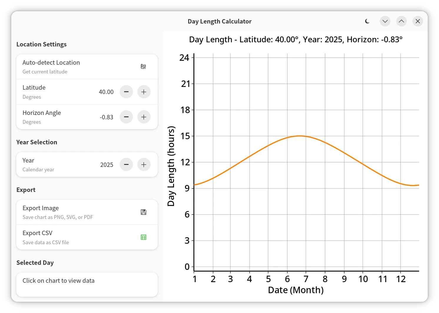 |
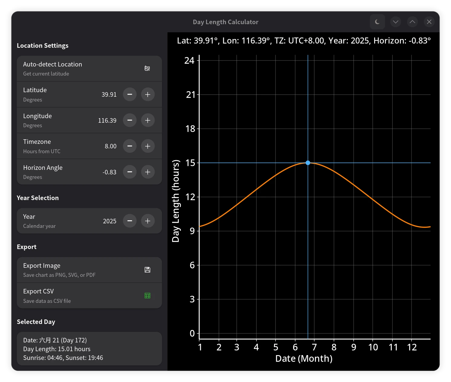 |
|---|---|
| 白昼时长计算器(浅色模式) | 白昼时长计算器(深色模式) |
-
本文采用CC-BY-SA-4.0协议发布,但本文代码采用LGPL v2.1+协议公开 ↩
赞赏本文
| 支付宝 | 微信支付 |
|---|---|
 |
 |